El Nino Could Bring Extreme Heat: What You Need to Know?
Duwi Setiya Ariyanti • Author
10 July 2026

40
• 8 Minutes Read
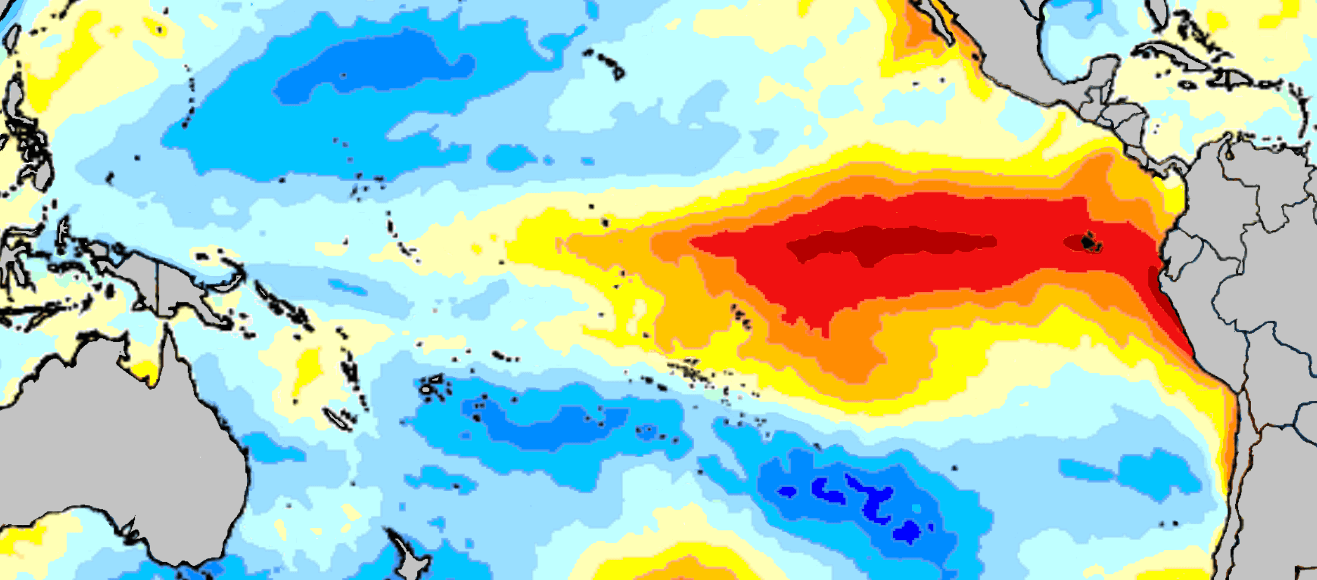
Image: Maulucioni/Wikimedia Commons
Although droughts occur annually, the risk of El Niño this year has quietly worsened. The threat of heat stroke, cardiovascular disease, wildfires, and crop failure are said to be among the risks of El Niño 2026. Some even predict that this year's El Niño will be stronger than previous years.
But what exactly do we need to know about El Niño? How does the intensity or strength of El Niño affect the world, and Indonesia in particular?
To better understand El Niño, this #AskTheExpert article features an interview with Supari, Head of the Monthly and Seasonal Prediction Working Team at the Indonesian Agency for Meteorology, Climatology, and Geophysics (BMKG).
What exactly is El Nino, based on facts and data that the public should know?
El Niño is a climate anomaly phenomenon that occurs when sea surface temperatures in the central and eastern Pacific Ocean become warmer than usual.
This warming weakens the trade winds, shifting the center of cloud and rain formation from the western Pacific Ocean—including Indonesia—to the central and eastern Pacific Ocean. This results in Indonesia receiving less water vapor, leading to decreased rainfall.
El Niño is not a natural disaster, but rather a recurring natural phenomenon that occurs irregularly, usually every 2-7 years. El Niño typically begins in the second half of the year and can continue into the first half of the following year.
How does El Nino differ from a normal dry season?
The dry season is a normal part of Indonesia's climate cycle, occurring regularly each year as a result of the active Australian monsoon. El Niño, on the other hand, is a global climate phenomenon triggered by anomalous sea surface temperatures in the Pacific Ocean and does not occur every year.
More specifically, El Niño and the dry season can be distinguished in several ways. In terms of time scale, the dry season occurs annually as part of Indonesia's annual climate cycle. El Niño, on the other hand, occurs less frequently, generally every 2–7 years, and lasts about 9–12 months (and possibly longer).
In terms of spatial scale, the dry season in Indonesia occurs at a regional scale and varies across regions. Meanwhile, El Niño is global in scale, affecting atmospheric and climate patterns worldwide, including Indonesia.
How is El Nino related to climate change?
Numerous studies suggest that global warming has the potential to alter the characteristics of the El Niño–Southern Oscillation (ENSO), the Pacific Ocean sea surface temperature anomaly encompassing El Niño and La Niña, in the future. While uncertainty remains about the magnitude of these changes, a growing body of climate modeling suggests that extreme El Niño and La Niña events may occur more frequently than in the past.
These changes are linked to changes in ocean temperature distribution, heat content in the upper ocean, and changes in tropical atmospheric circulation, which collectively influence ocean-atmosphere feedback mechanisms. A warmer atmosphere holds more water vapor, so when ENSO occurs, its impact on rainfall patterns can be more extreme, resulting in both droughts and heavy rainfall.
Thus, climate change not only shifts seabed conditions that affect the interpretation of the ENSO index, but also has the potential to change the frequency, characteristics, and impacts of ENSO on the global and regional climate system, including in Indonesia.
What are some of the common myths about El Nino that are still widely believed ?
The first myth is that El Niño means no rain at all. In fact, El Niño does reduce rainfall. In areas with very low rainfall during the dry season, El Niño can indeed cause prolonged dry conditions with no rain for days.
However, in areas with relatively high rainfall even during the dry season, such as Kalimantan, precipitation generally continues throughout El Niño, but with lower intensity.
The second myth is that El Niño affects all regions in Indonesia equally. In reality, the impact of El Niño varies from region to region, depending on local climate characteristics. North Sumatra and Aceh are among the regions in Indonesia that are not significantly affected.
The final myth is that El Niño inevitably causes heat waves like those in Europe. In reality, Indonesia can experience warmer temperatures than usual, especially during the day, due to reduced cloud formation, resulting in clear skies and maximum sunlight. However, temperatures in Indonesia do not reach the extreme levels associated with heat waves in subtropical countries.
How can El Nino become a phenomenon that poses serious risks?
Although the El Niño phenomenon can continue into the first half of the following year, its peak impact in Indonesia occurs between June and November, which coincides with the dry season in Indonesia.
A strong El Niño can lead to the risk of severe drought, particularly in areas with climatologically low monthly rainfall, such as West Nusa Tenggara (NTB) and East Nusa Tenggara (NTT). This risk can also occur in areas with geologically limited water resources.
What are BMKG’s projections for this El Nino and its potential impacts?
Based on the BMKG's monthly rainfall forecast, many regions are expected to experience below-normal rainfall from July to October 2026. This situation requires vigilance as it could lead to further impacts such as drought on agricultural land, resulting in crop failure, and an increased risk of forest and land fires due to the dry and hot climate. Areas likely to experience below-normal rainfall include East Java, Sulawesi and South Kalimantan, South Sumatra, and West and South Papua.

Image: BMKG
What mitigation and adaptation measures should the public take to stay safe during El Nino?
The BMKG recommends that people conserve water, harvest and store rainwater when available, prepare water reserves to face the peak of the dry season, and avoid burning land or waste in open spaces.
Farmers are advised to adjust planting schedules and choose crop varieties that are more adaptable to dry conditions. They should also reduce outdoor activities during daytime when temperatures are higher than usual and continue to monitor the latest weather and climate forecasts.
What is the outlook for future El Nino’s events, and why is it important for people to prepare?
The ENSO (Sea Surface Temperature Anomaly in the Pacific Ocean, which includes El Niño and La Niña) phenomenon is a natural cycle that recurs continuously, although its timing and intensity vary. Therefore, preparedness is crucial not only for the current El Niño but also as part of long-term climate risk management.
The onset of El Niño can generally be predicted up to six months in advance, providing ample time to develop mitigation plans. Therefore, the public should regularly monitor weather and climate information from the Meteorology, Climatology, and Geophysics Agency (BMKG) to keep track of climate developments. BMKG continuously updates its ENSO analysis and predictions based on constantly evolving atmospheric and ocean conditions.
What measures should different stakeholders take to prepare for the risks posed by El Nino?
In Indonesia, El Niño can have cascading impacts across various sectors, necessitating appropriate sector-specific measures. In the agricultural sector, these impacts include dry farmland, delayed or failed planting seasons, potential pest outbreaks associated with prolonged drought, and decreased crop production (rice, corn, soybeans, etc.), contributing to rising food prices.
In the forestry sector, El Niño causes vegetation to become drier and more flammable, increasing the likelihood of forest and peatland fires. This can damage ecosystems and wildlife habitats. Another consequence is increased carbon emissions from forest and peatland fires.
In terms of air quality, smoke from forest and land fires increases concentrations of PM2.5 and PM10. Reduced rainfall also causes pollutants to linger longer in the atmosphere, due to the lack of rainfall to wash them out, especially in areas affected by forest and land fires.
From an energy perspective, low river flows and lowering reservoir levels reduce hydroelectric power generation. Meanwhile, electricity demand increases due to the use of air conditioners (ACs) and fans. As a result, areas that rely heavily on hydroelectric power are at risk of power supply disruptions during extreme conditions.
In the fisheries sector, changes in sea surface temperatures and ocean circulation affect fish distribution, potentially shifting fishing grounds. In some waters off southern Indonesia, increased upwelling—the movement of cooler, deeper ocean water to the surface—can increase the productivity of certain capture fisheries, but the benefits are not evenly distributed across the country.
Furthermore, from a water resources perspective, decreased rainfall leads to decreased river discharge, reduced water reserves in reservoirs, ponds, and lakes, which can impact the availability of raw water for households, agriculture, and industry. Ultimately, the risk of hydrological drought increases.
Therefore, addressing the risks posed by El Niño requires collaboration across all sectors. Each sector is expected to take appropriate measures to mitigate the impacts of El Niño.